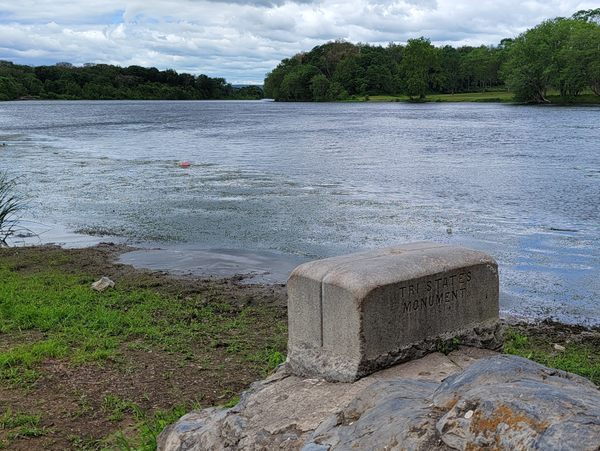
Full disclosure: The Tri-States Monument does not, as is sometimes claimed, actually mark the location where the boundaries of New York, New Jersey, and Pennsylvania meet. The confusion is understandable; the bronze United States Coast and Geodetic survey disc and scored granite marker give the appearance of authority and precision. However, as the nearby Witness Monument makes clear, the state boundaries actually intersect about 475 feet west of the Tri-States Monument, in the middle of the Delaware River. If you are particularly literal, you have been warned.
Also known as the Tri-States Rock, the monument was set in place in 1942, replacing earlier, less permanent, or damaged markers. Approximately a half cubic yard in size above bedrock, “Tri-States Monument” is chiseled into the north face. The top is engraved with the initials of the three states and grooves symbolically representing the state boundaries. The federal survey disc, a triangulation station now under the jurisdiction of the National Oceanic and Atmospheric Administration, dates from the same year.
Like the Tri-States Monument, the Witness Monument 25 feet away was originally engraved in 1882 and placed at its current location in 1942. “Boundary Monument” and the earlier date are inscribed on what is also called the Reference Monument, along with verbal descriptions of the marker’s location relative to the Tri-States Monument and the true tripoint of the three states. Also noted for posterity are the names of three New Jersey and three New York commissioners, as well as the surveyors from each state, who certified the two monuments’ locations.
The granite markers are located on what is known as Carpenter’s Point, the tip of a short peninsula between the Delaware and Neversink rivers that is home to the Laurel Grove Cemetery, established in 1856. Aside from its geopolitical significance, Carpenter’s Point is—the traffic overhead on Interstate-84 notwithstanding—a peaceful place to view the Delaware River.
Know Before You Go
When using GPS to navigate to the Tri-States Monument, it is advisable to use that place name or the cemetery’s street address (247 East Main Street) as a destination. Geographic coordinates (longitude and latitude) may direct visitors to a location on I-84, above the monument. The entrance to Laurel Grove Cemetery is from US-6 (East Main Street), immediately west of the bridge over the Neversink River. The internal road is one-way, clockwise, and there is parking near the monuments. It is also possible to park where the cemetery road exits at South and High streets and walk a half-mile to the monuments.
The Tri-States Monument is near the eastern shore of the Delaware River. The descent from the parking area and subsequent return are generally manageable but rocky and moderately steep. Reasonable care should be taken, especially if the water is high, for example after the spring snow melt or following heavy rain. The Delaware River can appear deceptively placid but at Port Jervis, averages 7,900 cubic feet of water per second, all flowing towards the Atlantic Ocean.

